This is not a "blog" in the sense of a daily journal but a place for me to post GPS trail maps of mountain biking and hiking trails, particularly but not exclusively, in the western Greenbelt in Ottawa, Ontario.

Hybrid & E-Bikeable Routes and National Capital Region Cycling Routes and Resources are also included on this site,

Date codes do not reflect actual posting dates but are manipulated to allow me to order the posts in a thematic order.

Showing posts with label maps. Show all posts

20001224

Backroad Mapbooks GPS Map Review (Ontario)

Background

Up until now I had used Topo Canada (ver. 2) from Garmin on my GPS for navigation and mapping, along with Google Earth. I was not completely happy with the detail it provided nor the fact that it was getting out of date. When ver. 4 came along (skipping ver. 3) I was interested in possibly upgrading as it did include some new 3D software functions. However, from what I could tell from the sample map utility on the Garmin website the maps did not seem to be particularly updated.

I also experimented with TopoFusion which provides access to the Natural Resources Canada map server and the most recent Canadian government maps. That provided an alternative view but it was still not completely satisfactory, as they are just flat maps without road or street names, etc.

So I was quite interested when the Backroad Mapbooks people contacted me to ask if they could use my GPS maps in a new product they were developing for Garmin GPS units, as I already owned several of their print volumes for parts of Ontario. Those discussions ended up with my offering them the GPS map data with no conditions but suggesting they provide me with a free copy of their Ontario GPS product, to which they responded positively.

I have had it for a few weeks now and it has become the default GPS map on my GPS unit for Ontario, as well as the most used map on my computer. Hopefully, as I continue to provide them with new and updated trail data they will continue to provide me with map updates.

The Review 
 
The first thing I should say, as I have learned as I have worked on writing this is that this should be considered a preliminary review (although I likely won't write another one as I think this will capture the spirit of the product and most of what I want to say) because I sense I still have a lot to learn about the depth and capabilities of this mapping software.

Let us skip ahead to the conclusion to say that it seems obvious from comparing Garmin's Topo Canada to Backroad Mapbooks Ontario GPS Map that Garmin is a technology company and Backroad Mapbooks is a mapping company.

First I should note that I did have a bit of a problem with my first attempt at installation until I went back and carefully read the actual instructions. That is to say, the install is not as intuitive as some of us lazy folk who hate to read instructions would like, but as long as you read the instructions all will be well.

Backroad Mapbooks GPS Maps work with MapSource so you do not have to learn a new software interface on the GPS or computer. One of the advantages of this is that it allows the Backroad MapBooks people to concentrate on what they do best, map-making rather than software development. Although it would be interesting to see what kind of software features they would add, based on their mapping experience.

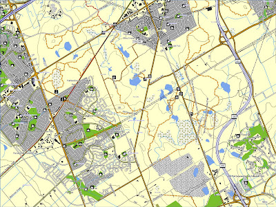
The look, both on the GPS and computer is different, primarily because there is more detail provided, and that took some adjusting but I quickly decided I preferred BackRoad Mapbooks (BRM) to Garmin's Topo Canada (TC). BRM uses 10,000 and 20,000 scale maps rather tham TC's 50,000 and 250,000 scale maps so I was expecting to see a difference there. However the biggest difference is in what information BRM provides that TC does not.


Map of Choice For Outdoorspersons

One of the first things I noticed was that BRM has trails marked, which TC does not (with a few very rare exceptions). In particular they have the official NCC Greenbelt trails that I ride on (and map) included. I look forward to them adding my GPS maps which includes all the undocumented Greenbelt trails that are not on the official Greenbelt maps, along with the South March Highlands trails which they also lack at the moment.

Seeing this led me to check out the maps on the computer for trails I have recorded in Algonquin and Killarney provincial parks and they were on the map also, along with other trails in the parks. A quick overview of the Ontario map showed considerable trail coverage across the province, including the Bruce Peninsula National Park and the Bruce Trail so I will assume there is pretty decent coverage of all provincial and national parks.

Also included is what appears to be pretty comprehensive coverage of snowmobile trails, which provides a huge market for the product, as well as canoe routes and portages. Another quick review indicates that the map software includes an extensive collection of Points of Interest (POIs). The Backroad Mapbooks website provides an overview of the Ontario GPS Map Features as well as other information and tutorials on their GPS maps products.

This is indeed the GPS map of choice for outdoorspersons.

I also noticed pretty decent coverage of local walking/cycling paths when I was riding and similar decent coverage on the computer map, though there is definitely some room for improvement there. Indeed the biggest complaint I would have with the BRM map is that it is not perfect. 

Computer Map Comparisons
(Click on images to enlarge)

Google Earth View

TopoFusion Natural Resources Canada Map

Garmin Topo Canada Map

BackRoad Mapbooks Map

Unclassified Roads

One thing that did surprise me with TC was when it routed me from Killarney to Sudbury via roads that no longer exist, except as trails and that may not even be open because they go through Department of National Defence lands at the Old Burwash prison site. So I wanted to see how BRM handled the routing, and it used open main roads. BRM does have those roads marked but as "unclassified roads" rather than local roads.

I had already come across this caution about :"unclassified roads" in another review

There's quite a difference, isn't there? While fourwheeling and testing the maps, I did notice that the maps showed some roads that didn't exist, but that's because they were now heavily overgrown and had become single tracks. Personally, I would much rather see them on the map, than not see them at all. These were all marked as "unclassified roads" which was fair warning. The fun in exploring is to see which of these unclassified roads are actually passable and can take you to new places. And in that regard, Backroad GPS Maps is extremely useful for that kind of trip planning. In fact, it's dangerously easy to lose hours of your time, poring over potential trails to explore, and finding possible routes from one trail system to another. But if you're the kind of person that just wants to know where the known-to-be-good roads are, then just stick to using the roads that aren't marked as unclassified.

I must say that I agree with that view, as the more information for people searching for possible hiking or mountain biking trails the better. However BRM might want to put a caution on their "Legend" about unclassified roads.


Updates

One of the things that was annoying about TC was that updates to the map were not available and the only way to update the map was to purchase the newer version of the software. With BRM annual updates are available at a reasonable cost and there is a progam that provides free updates for users that submit trail and Point of Interest information.

It is very clear that BRM wants to make their product as complete and updated as possible for the outdoorsperson and is engaging the user community in that pursuit. My only concern would be that they ensure reasonable review and control over what is included from the submitted information.

Suggested Improvement

I have one suggested improvement and that relates to the comprehensiveness and extent of information provided on the map. There is a fine line between comprehensiveness and clutter and drawing that line is difficult. Rather than arbitrarily limiting the information included on the map I would suggest BRM let the user decide what information is viewed on the maps, not just in terms of degree (less to more) but in terms of categories. I would suggest the use of an interface similar to what Google Earth uses to show what Layers are shown. I would also suggest that users be able to select the categories shown both on the computer and GPS through a computer interface (easier to use than a GPS interface) and then synch the choices with the GPS.


Conclusion

It seems obvious to me, from comparing Garmin's Topo Canada to Backroad Mapbooks Ontario GPS Map, that Garmin is a technology company and Backroad Mapbooks is a mapping company run by outdoorspersons who truly love and believe in what they are doing.

Update 2012-05-05

As of Version 3.0 my GPS maps from this site current as of today have been added to the GPS and computer maps. 

Posted 2011-11-07 
Updated 2012-05-05

19901230

Richard's Hybrid & E-Bikeable Routes - Introduction

This section of the website differs from the rest as it does not involve comprehensive maps of pathway systems, like my trail system maps, as they already exist and will be linked to below.

Since I ride my E-Bike (previously my hybrid) on the local roads and paths, as well as my mountain bike on the trails I thought I would post some of my favourite routes for people that are looking for paved, or easy gravel or sand-dust, routes to ride. Since I ride both throughout the season I will not wait till I finish mapping all the trails to start posting these maps.

For specific hybrid & e-bikeable routes go back to the Jump Links. More routes and maps will come later but below see existing maps of the local pathway systems and cycling routes.

National Capital Region Cycling Routes and Resources

Routes and Maps, including Official Cycling Map for Ottawa-Gatineau and the Outaouais Region


Hans on the Bike Ottawa Cycling in Ottawa (including Ottawa Cycling Maps) 

City of Ottawa Self Guided Cycling Tours of Rural Cycling Routes: CBC Article;  Maps


Ottawa OpenStreetMap

Ottawa Valley Recreational Trail (Rail Trail)

Log Driver's Waltz Bikepacking Route - Ottawa Valley and Outaouais regions:  
 
OttawaVeloOutaouais – Biking around Ottawa and the Outaouais


GPS gpx Files

The gpx files for my hybrid routes can be downloaded by clicking this link:

GPX files - Google Docs

If you do not have a GPS unit you can still use the gpx files by loading them onto software that has background maps such as TopoFusion, or Google Earth, and see the detailed routes over the maps or satellite image.

If you do download the gpx file please email me at richardw.woodley@gmail.com and let me know so that I have an idea of how many people are downloading and using the files.

Posted 2012-04-02
Updated 2024-04-20

19901220

Bridlewood to Stittsville Paths, Ponds and Creeks Hybrid & E-Bikeable Route

Updated May 2022 to add new paths in the new subdivisions southwest of Terry Fox Drive between Terry Fox Drive & Robert Grant Avenue.

Annotated Map with Ponds and Creeks Indicated 

(Double Click to Enlarge Full Size)


Aerial View Map

(Double Click to Enlarge Full Size)


 The Route

PRELIMINARY NOTE: This reads more complicated than it is. Once you are on the route it is quite intuitive.

This is a pleasant approximately 35 kilometre bike ride on local pathways from Bridlewood in Kanata to Stittsville and back passing several ponds and creeks, with a few short sections on roadways.

The route starts along Equestrian Drive across from Pony Park, going up the hill on the pathway along the large Bridlewood hydro line. It follows the hydro line, crossing a few roads until it intersects with the smaller Bridlewood hydro line where you go left crossing a few more roads till you reach the Trans-Canada Trail (TCT).

You go left again on the TCT and cross Eagleson road and take the first path to the right. Take a left on Rothesay Drive for half a block and go right on the pathway through the park staying to the left till you reach Old Colony Road which you follow for a short bit till you turn left again at the Community Mail Boxes.

Follow the path till just before the bridge over the creek where you go left again down to Castlefrank Road. The creek will be in a ravine on the right of the path. Rejoin the path on the other side of Castlefrank Road where the creek moves to the left side of the path and continue to follow the path over a bridge where you go right and the creek moves to the right side of the path. Cross Rickey Place and the creek moves to the left side of the path.

You will then have to cross Terry Fox Drive (TFD) where the path goes to the left. You might wish to cross TFD at the corner of TFD & Winchester Drive. The creek will be on the left until it becomes a pond and then disappears into a culvert. Continue on the path until you rejoin the Trans Canada Trail (TCT).

Turn right onto the TCT and continue past the roundabout at Robert Grant Ave till you reach Iber Road. Go right along the southwest side of Iber Road about a block then turn left onto the path along the pond till you get to Cinnabar Way.

Go right on Cinnabar for about a block then go right onto a pathway following it (you will cross a few streets) till you get to a little pond, creek and bridge. Do not go over the bridge. Continue until the path becomes paved and take the pathway to the right beside the large pond.

At this point you will go in a loop and return to this point. Follow that path, staying to the left, till you get to Trailway Crescent. Go right on Trailway Crescent, After a couple of blocks you will see a paved path to the right. Continue past it and follow Trailway Crescent around a curve to the right till you get to another paved path on the right. Follow that, staying left all the way back to the pond where you started on the loop.

Go right and continue till you cross Abbot Street and rejoin the Trans-Canada Trail (TCT). Go right on the TCT, past Sacred Heart High School all the way to the park at Stittsville Main Street. Cross Main Street and continue on the TCT till you reach West Ridge Drive.

On the other side of West Ridge drive you will divert from the TCT taking the path on the left over the bridge and along the creek on the left. Follow the path as it turns rightward, becoming roadway for a short bit and then going into the bush till it reaches Hazeldean Road.

Turn around at the end of the trail and follow the pathway back to the TCT at West Ridge Drive. Continue following the TCT all the way back to Robert Grant Avenue at École Secondaire Catholique Paul-Desmarais.

Turn right and follow the pathway alongside Robert Grant Avenue to Cope Drive where you turn left and follow the pathway along Cope Road till you come to the first pond. Follow the pathway alongside the pond and cross Continental Avenue and continue following the pathway alongside the creek crossing Rouncey Road.

Go right and go around the next pond (going by the LCBO near the Walmart) following alongside Terry Fox Drive. Near the end of the pond take a short dirt path that connects to the paved pathway beside the next pond. Continue following Terry Fox Drive alongside the pond. You have to go off path for about 10 metres till you cross Westphalian and continue on the paved path back to the TCT.


Cross Terry Fox Drive, continue about a block on the TCT then go right alongside the pumping station and follow the driveway/road to Akerson Drive and turn right. Go about a block then turn right onto the pathway through the park and go own to the path along the creek and continue towards the left Continue along the creek past Cope Drive till you come to a bridge over the creek. Take the path on the left, then go right along the road and around and take the path to the right to the path along Eagleson Road, go right to Fernbank Road and cross Eagleson Road continuing in the same direction along the path to Bridgestone Drive.

Go left along the path along the south side Bridgestone Drive and then to the right along the smaller pond. Go past the pond and cross Emerald Meadows Drive. Go to the left around the larger pond doing a figure eight over the bridge and all around the pond . You will notice a large variety of water birds on the pond, including herons, egrets, ducks and geese. Take a left northeast alongside the playground area to Meadowbreeze Drive. The route essentially ends there.

To continue to the start point go left on Meadowbreeze, cross Grassy Plains Drive where the name changes to Eagleview Street. Turn right at Milner Downs Crescent and follow it around and across Bridgestone Drive where the name changes to Spur Ave. At the end of Spur Ave, turn left on Equestrian Drive and continue to the start point.

Hopefully you will have had an enjoyable ride.
 
Postscript The Math: 9 ponds, 6 creeks

Altitude Profile


Slide Show

Viewing Slide Show Full Screen Recommended

GPS gpx Files

The gpx file for this route (and other routes and trail systems) can be downloaded by clicking the link below:


If you do download the gpx file please email me at richardw.woodley@gmail.com and let me know so that I have an idea of how many people are downloading and using the files.

Posted 2017-10-29
Updated 2022-05-18
 

19901210

Bridlewood to Britannia and Return Hybrid & E-Bikeable Route

This is the first of my hybrid & e-bikeable routes to be posted on my GPS Trail Maps website.

This is an enjoyable 38 kilometre route that is almost entirely on paths (or easy gravel/dirt trails) with only a few blocks of connecting roads in a couple of places. Much of it is through forested land in the Greenbelt.

The Maps
(Double Click to Enlarge Full Size)


The Route

PRELIMINARY NOTE: This reads more complicated than it is. Once you are on the route it is quite intuitive.

The route starts in Bridlewood along Equestrian Drive (not far from the Real Canadian Superstore parking lot on Eagleson Road) where the large hydro line crosses the street.

You start by going up the hill that comes out at the the sidewalk and along a paved path that becomes gravel. It follows the large hydro line east, crossing a couple of streets, until it reaches the entrance to NCC Trail 24 to the left heading north.

This is a wide gravel and dirt forest access road, Turn left and follow it north (passing another wide access road to the right) until you intersect with the old railway right of way (now the Ottawa-Carleton Trailway and part of the Trans-Canada Trail), a wide gravel and stone dust path.

Turn right heading northeast on the Trans-Canada trail and cross the trestle over Robertson Road, then go the left and then west for a short distance before heading north on the Greenbelt Pathway. There will be a gate blocking motorized traffic and a farm field along both sides.

The gravel Greenbelt Pathway travels through wooded areas and crosses Timm Drive before going underneath the Queensway and crossing Corkstown Road. It continues until it intersects the paved Watts Creek Pathway at the bottom of a hill.

At this point you can choose to take a shorter 22 kilometre route if you wish by turning left and heading north on the Watts Creek Pathway until you come to an intersection and the path goes left, west under the rail line. If you wish to do that skip ahead to (Shorter Route Continues Here).

To continue to Britannia turn right heading east on the Watts Creek Pathway and continue to Moodie Drive.

Cross Moodie Drive and follow the path alongside a field and across Corkstown Road. The path then stays near the Queensway going east until it veers away and comes out at Holly Acres Road.

At Holly Acres Road use a dedicated cycling crossing and continue to Carling Avenue where you cross at another dedicated cycling crossing. At that point go right following the Ottawa River Pathway northeast along the Ottawa River until you reach Britannia Beach.

At this point I usually ride around the pier and along the edge of the grassy area by the river before rejoining the Watts Creel Pathway heading back southwest towards Moodie Drive.

After you cross Moodie Drive divert from the original route by going right, north on the paved path and take the first left, west on a gravel path. Follow the gravel path, staying left at intersections till you come to an open area where you can see the Watts Creek Pathway ahead and a partially open gate to the right. At this point we go off “official” paths for a short distance.

If you do not want to leave the official paths, skip the next paragraph and continue straight to the Watts Creek Pathway and turn right heading west. Continue on the paved path until you come to an intersection and the path goes left, southwest under the rail line.

To continue on the planned route go right through the gate heading west and follow the trail through grassy and wooded areas till you come to a fence, Go left along the fence a very short distance until you can access the wide gravel path, Go left on the wide gravel path until you come to the paved Watts Creek Pathway and go right heading northeast until you come to an intersection and the path goes left, southwest under the rail line.

(Shorter Route Continues Here)

At this point you go under the rail line and continue to follow the Watts Creek Pathway over a creek and rail line till it ends at the top of a hill looking down where the paved path continues under March Road. Follow the path under the road and between houses and alongside a field till you get to Teron Road, At this point we are on a short road ride, Go left, south on Teron Road and cross Campeau Drive and continue till you have to turn right going southwest. Along this stretch that parallels the Queensway you will alternate between short local roads and paths through little parks till you get to a storm-water management pond.

You can leave the planned route here if you wish and ride around the pond.

On your left (from the original approach) will be a pedestrian/cycle overpass across the Queensway. Cross over that and continue southeast along Whitney Drive to Katimavik Road.

Cross Katimavik Road and take the middle pathway that runs southeast along a parkland corridor. You will cross a street and go up a hill to an intersection in the path. Go left and then right and right again around the schoolyard and come out on Chimo Drive.

Now we are on the road again for a couple of blocks. Go right, southwest uphill on Chimo Drive then go left on Anik Way which becomes Pickford Drive, Follow Pickford Drive for about two blocks southeast till you come to the parkland corridor again and take the path southeast along the parkland corridor, You will cross several streets until you reach Pickford Drive again. Go left on Pickford Drive and then right on Irwin Gate and continue till you get to Hazeldean Road.

Cross Hazeldean Road onto Carbrooke Street and turn left into the Hazeldean Mall parking lot. Drive through the parking lot till you come out at Abbeyhill Drive. (The reason to go through the parking lot is to get a 4-Way Stop at Abbeyhill Drive.) Turn left on Abbeyhill Drive and proceed to Eagleson Road.

It is best to dismount at Eagleson and cross the road via the pedestrian crosswalk.

On the other side of Hazeldean Road is a dirt/gravel path. Take it and turn right at the intersection. Continue until you reach Shetland Park where the path becomes paved and continues southeast alongside the small Bridlewood hydro line crossing the Trans-Canada Trail (old railway right of way). You will intersect with the large Bridlewood hydro line you started on. Turn right and go southwest until you reach the beginning of the route.

Hopefully you will have had an enjoyable ride.

Altitude Profile


Slide Show
 
   
 Viewing Slide Show Full Screen Recommended

GPS gpx Files

The gpx file for this route (and other routes and trail systems) can be downloaded by clicking the link below:

GPX files - Google Docs

If you do download the gpx file please email me at richardw.woodley@gmail.com and let me know so that I have an idea of how many people are downloading and using the files.

Posted 2017-06-01

19901205

Bridlewood, Bruce Pit & Britannia Loop Hybrid & E-Bikeable Route

This is a pleasant 40 km bike ride mostly through paved paths in green corridors as well as some forest trails and suburban streets. 


Route Description and Directions with Detailed Maps

PRELIMINARY NOTE: This reads more complicated than it is. Once you are on the route it is mostly intuitive.

Map 1

The first portion of this ride is primarily along forest trails.

You start along Equestrian Dr. across from Pony Park (which is across from the Real Canadian Superstore between Eagleson Rd. and Equestrian Dr.) and go up the hill onto the pathway following it past a school and along along the large hydro line and continue to the end. Then turn left onto the wide portion of Trail 24 and continue till you meet the wide trail to the right (still Trail 24) and follow it to Bells Corners. You come out a housing complex parking lot.

Map 2

This portion of the route is along suburban streets.

At the parking lot go right and follow Forester Cres. around to Seyton Dr. and go right to Old Richmond Rd. (across from the Mosque) then go left and follow the first right onto Moodie Dr. in a semi-circle. Take the first left and follow Anwatin St. to the end, then go left and follow Sycamore Dr. to the end, then go right and follow Longwood Ave. to the end. Go left on Ridgefield Cres. and take the first right, Evergreen Dr. and the first left, Delta St., then turn right on Stinson Ave. At the end of Stinson Ave. ride onto the pathway near Bell High School going right onto Bruin Ln. and left onto Bruin Rd. Continue across Cassidy Rd. and over Hwy. 416 to the path by Bruce Pit.

Map 3

This next section is primarily on paved paths through green corridors through parks or behind houses.

After crossing over Hwy 416 turn right then left past the parking lot then keep right until you come to the paved pathway on the left. Follow the pathway through a green corridor crossing McClellan Rd continuing till you get to Canfield Rd. Turn right and follow Canfield Rd. until it crosses Greenbank Rd. and becomes Craig Henry Dr. Continue until just before Shoreham Ave. where you turn left onto a paved pathway. Follow the pathway through parks and along a green corridor crossing Centrepointe Dr. Twice, until you make a 90 degree left turn.

Map 4

This section follows green corridors along Pinecrest Creek and the Ottawa River and goes alongside the equestrian park.

After the 90 degree left continue north (you will be running parallel to Algonquin College on the right). At Navaho Dr. take a short jog to the left and then right and continue north along the Pinecrest Creek Pathway crossing Baseline Rd, Iris St., going under Hwy 417, Carling Ave., and Richmond Rd. Continue to the Ottawa River Pathway and turn left onto the pathway and continue past Mud Lake and Britannia Park. Continue to Carling Ave., beside the water park, and cross Carling Ave and continue south on the Watts Creek Pathway. Cross Holly Acres Rd. on to Aero St. And immediately go left back onto the pathway and continue riding parallel to Hwy 417 until you cross Corkstown Rd. Continue around a field till you cross Moodie Dr. and continue on the Watts Creek Pathway until you see a dirt path on the left, going up hill. That is the Greenbelt Pathway West.

Map 5

This section is primarily along forest trails.

Turn left and go up the hill following the Greenbelt Pathway, cross Corkstown Rd. and go under Hwy. 417 and continue until you cross Timm Drive. Continue and cross to the right over Robertson Rd. on the old railway trestle. Continue until you come to a 4 way intersection with a wide trail on the left (Trail 24) and follow that to the end were you turn right onto the large hydro line and continue to the start point on Equestrian Dr,. across from Pony Park.

Hopefully you will have had an enjoyable ride.

Altitude Profile

Slide Show 

I plan to add a slide show to this route, probably in the Spring of 2024

GPS gpx Files

The gpx file for this route (and other routes and trail systems) can be downloaded by clicking the link below:

 GPX files - Google Docs

If you do download the gpx file please email me at richardw.woodley@gmail.com and let me know so that I have an idea of how many people are downloading and using the files.

Posted 2023-10-13

19901125

Britannia, Ottawa River, Rideau Canal, Experimental Farm, Pinecrest Creek Pathways Hybrid & E-Bikeable Route

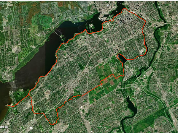
This 33.8 km loop, which follows the Ottawa River, Eastern Rideau Canal, Experimental Farm and Pinecrest Creek pathways can be combined with the Bridlewood to Britannia 37.7 km loop for a longer loop of 71.5 km.

The Maps
(Double Click to Enlarge Full Size)

The Route

PRELIMINARY NOTE: This reads more complicated than it is. Once you are on the route it is quite intuitive.

Starting at the pier at Britannia Park you follow the Ottawa River Pathway past Westboro Beach, the Chief William Commanda Bridge, and the National War Museum. Be sure to follow the solid yellow lines as you go under the Ottawa River Parkway and Wellington Street and then continue past the Parliament Buildings (up above) to the Rideau Canal.

At the canal you will have a granny gear ride up the hill. After you go under Wellington Street you will have two staircases to walk your bike down along a wheel ramp provided along the side of the steps. After you pass the National Arts Centre keep your eye open for the path on the right that takes you up to the Rideau Canal Eastern Pathway. Follow the pathway to Dow’s Lake where you go behind Canadian Forces Reserve Barrack Dow's Lake (HMCS Carleton) and continue to the next set of locks across from Carleton University.

At the locks go right and follow the road across Prince of Wales Drive onto the Experimental Farm. Turn right at Morningside Lane and left at Cow Lane and continue along the Experimental Farm Pathway. When you get to Fisher Avenue you have to go right a short bit till you continue along the Experimental Farm Pathway on the left. You will have a long (but not steep) annoying climb till you get to Merivale Road and then there will be a relatively steep downhill just before Maitland Avenue.

After you cross Woodroffe Avenue by the fire station you join the Pinecrest Creek Pathway. Follow the pathway till you get to Iris Street and cross over to the left side of the transitway and continue along the Pinecrest Creek Pathway till you join the Ottawa River Pathway and go left back to Britannia.

Hopefully you will have had an enjoyable ride.

Altitude Profile
Slide Show

   
Viewing Slide Show Full Screen Recommended

GPS gpx Files

The gpx file for this route (and other routes and trail systems) can be downloaded by clicking the link below:

GPX files - Google Docs

If you do download the gpx file please email me at richardw.woodley@gmail.com and let me know so that I have an idea of how many people are downloading and using the files.

Posted 2021-07-31

Labels

Followers

About Me

My photo
Richard W. Woodley was born in Sudbury, Ontario in 1950. He earned an Honours Bachelor of Arts in Political Science from Laurentian University where he was the News Editor of the student newspaper Lambda and active in student politics. He was active in the New Democratic Party and Waffle in Sudbury and Kanata, as well as Kanata municipal politics. He was a member of the Bridlewood Residents Hydro Line Committee (BRHLC) and creator of the now archived Bridlewood Electromagnetic Fields (EMFs) Information Service. He worked on Parliament Hill for 33 years indexing the Debates of the House of Commons (Hansard) and it's committees. Richard has been an outdoorsperson and environmentalist for most of his life and a life long cyclist who also mountain bikes.